Cold, wintry to start with the 'Beast From The East' and with a brief return of cold easterlies 16-18th
Whilst March may have been cold and felt like a winter's month with some notable and disruptive snowfall at the start, its final mean temperature wasn't actually that significant. When comparing this March to others in the historical record (Newton Rigg with a record back to 1914), March has finished below 3°c on twelve occasions (five of which were below 2°c) and this March doesn't even feature in the fifteen coldest!
However, it was cold and the month opened in the grip of a severe spell of winter weather that had begun on the 25th February and which peaked on the 1st, the start of the meteorological spring! The start of Spring this year was certainly more aligned with the equinox (20th) than the meteorological definition and come the month's end the daffodils were still to bloom.
Those winter conditions at the beginning of the month were virtually bordering on the extreme across parts of the county. There were numerous impacts from the heavily drifted snow: to travel, villages cut-off and requiring emergency supplies, being just some. Here at Maulds Meaburn the snow lay 20 cms deep (level depth) on the 1st following heavy snow overnight, but with the wind gusting upto 45 mph there was much drifting of that snow.
Recording an 'Ice day' (when the temperature remains below freezing), is unusual for March, but then two come along together (1st and 2nd - which along with the 28th Feb' made it three consecutive days). This really was a bitter cold period. However, despite the cold and the snow, it was probably the wind that was most notable - straight from the east, straight from Siberia and which cut straight through you.
And maybe because it all fell at the start of the month and had started in February, March might have 'got away with it' had warmer conditions then prevailed, but then we had the 'mini beast' later in the month.
During the month, there were: two 'Ice Days' (1st and 2nd), snow fell on six days and was lying on the ground (to a depth of at least 1 cm) on seven days (1st-5th and 18-19th).
MSLP of 1001.2 Mb was -11.3 Mb below the local average for March with low pressure dominant throughout the period 2nd- 15th and again at the months' end.
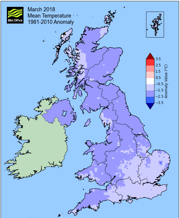
Overall a mean minimum of 0.15°c and a mean maximum of 6.75°c saw the temperature 2.0°c below the 1981-2010 average. It was the coldest since 2013 and of the ten now recorded, one has been colder and eight warmer. The highest maximum temperature recorded was 12.6°c (11th), the lowest minimum -6.5°c (1st).
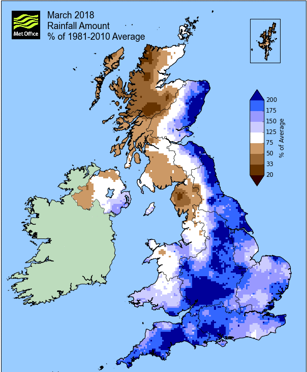
Rainfall of 69.2 mm (Crosby Ravensworth School 66.1 mm - Castlehowe Scar 80.1 mm - Reagill 48.0 mm) was 91.3% of average for 2008-17 and made it the driest March since 2013. Of the eleven now recorded, four have been drier and six have been wetter.
Winds were more prevalent from a NE-SE quadrant, not the usual SW�ly�s and the most likely reason as to why the rainfall was greater in Maulds Meaburn than Crosby Ravensworth this month.
At the Met' Office site at Newton Rigg, 42.0 mm (55.4%) made it the driest March since 2012 and in a series back to 1900, March has been drier in 33 years and wetter in 84 years (1yr of missing data). A mean temperature of 3.5°c is the coldest since 2013 and in a series back to 1952, 11 have been colder, 54 have been warmer and one year had the same mean temperature. In that longer series back to 1914, but with 5yrs missing, it would have been the 17th coldest and with two years having the same temperature.
Locally, rainfall percentages had a very wide variation and none more so than Seathwaite. With just 28.0 mm (8.8% of average) Seathwaite recorded by far its driest March for a long time, in fact back to 1900! In that time very few have recorded less than 100 mm in that time. To the east of the county a range of 60-70% of average was typical, but as the anomaly map below shows, the percentages reduced as you ventured further west.
Figures from the Environment Agency�s rainfall sites were, (figure in brackets being the monthly average for 1961-90) �Data kindly provided by the Hydrometry and Telemetry team of the Environment Agency (Penrith)�:
Kirkby Thore 35.0 mm (55.1 mm)
Haresceugh Castle (Kirkoswald) 57.85 mm (84.6 mm)
Brothers Water 100.88 mm (219 mm) and
Orton (Shallowford) 86.2 mm (128.0 mm [average for 1967-2017])
28.0 mm at Seathwaite Farm (Borrowdale - 319 mm [average for 1981-2010])
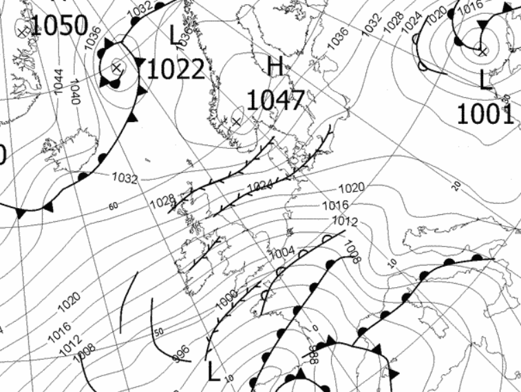
1st - 3rd The month began with the continuation of the strong E'ly flow from the end of February, the 'Beast from the East' - this was not the start of spring, this was severe winter weather.
The 1st would be the worst day of the entire event. Heavy snow overnight saw the day start with a cover 20 cms deep, a new record for this site and which would both see that snow continue throughout the day, but with the wind became stronger still. That wind would gust to 45 mph, causing that snow to drift and which resulted in the village being cut-off for a short while.
The temperature overnight into the 1st fell to -6.5°c and now the very cold theme would really bite. Like the 28th, the temperature remained below zero all day and would be the coldest March day in my ten years of records. A maximum temp of -1.2°c (29.8&176f) was made even worse due to a significant wind-chill. That wind was so strong, the snow dry and powdery, that the drifting had the affect of virtually stripping eastern facing fields of any snow at all - and the affect was that come the 2nd the level depth was down to 13 cms!
The 2nd would also remain below freezing, a maximum of just -0.5&176c making it a third consecutive day below freezing. The wind continued to cause further drifting, but now access in and out of the village had become that bit more straightforward. By the 3rd the temperature had finally managed to rise above zero and now a broad area of low pressure (LP) sat in the English Channel would take control of our weather. Snow still lay on the ground on the 5th and there were still overnight frosts, but the worst was over.
4th - 15th Low pressure (LP) would now dominate the weather through to mid month. Generally unsettled and changeable and gradually became much milder.
For much of the time the UK sat within a broad and fairly slack area of LP which had several centres and circled the UK like vultures. On days such as the 8-9th when we were clear of any fronts, we had some sunshine and it was quite pleasant, but fronts tied into the LP were never too far away and hence spells of rain were never too far away.
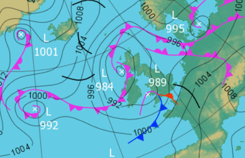 0000 Hrs 7th - Low pressure surrounds the UK, but having broadened and slackened
The heaviest spell of rain, 19.3 mm, came overnight into the 6th and which effectively washed away any remaining snow, with the next few days generally being mixed, until those sunnier days 8-9th. Rain did arrive late on the 9th as a frontal system moved south-north up the UK and which then gave a poor day on the 10th, a steady drizzle persisting all day.
The flow was now from the south and the 10th had become the first day of the month to attain 10°c and now clear of any fronts the 11th would be the stand-out day. Clear of fronts and still with S'ly flow we had decent amounts of sunshine and a maximum of 12.6°c (54.7°f) - but then it went downhill!
The 12th would only get to 5.9°c and was wet throughout, 9.3 mm (with the rain starting at 0700 hrs it also gave 4.9 mm credited back to the 11th). After a weak ridge of high pressure (HP) gave a quieter day (and a frost overnight) on the 14th, there began a subtle change to our weather.
LP to the SW of Eire, would move slightly north and become semi-static, but pushed an occluded front north across the UK. As that occlusion cleared north, the effect was to pivot the LP and draw in an ESE'ly airflow that was somewhat brisk. This had the strange effect of feeling cool and fresh as the 14th progressed - the thermometer had showed 11.2°c at 1300 hrs, but it was all downhill from there as that wind started to bite. Come the 15th that wind was now making itself felt and with a wet morning it all felt quite grim.
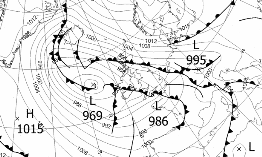
16th - 18th We then had the 'Mini Beast from the East' as once again it turned very cold, more so by day - the actual temperatures recorded were not that notable, but the wind-chill was significant.
HP once again sat over Norway and drew down a very brisk E'ly flow. With troughs developing in that airflow as the air began its journey across the North Sea, we saw spells of snow, mainly on the 17th. That snow was enough to give a covering on both the 18-19th and with drifting in that severely cold wind.
Temperatures overnight only fell as low as -4.0°c (18th), but the days, for mid March, were particularly cold, the 17th having only attained a maximum of 0.9°c.
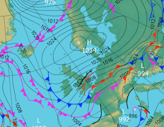
19th - 22nd Whilst HP remained in charge of the weather and indeed the same HP as the previous days, it now migrated away from Norway and by the 21st would be off the southern tip of Eire, thus allowing a W'ly flow over its top edge.
Subsequently it became milder, brighter and we also managed a couple of dry days - the temperature during the period being just over 8°c.
23rd - 31st LP systems then became the dominant feature through to the month's end. However, whilst there were some unsettled conditions, the majority of any rain that did fall during the period tended to do so overnight or was in the form of showers - it wasn't that bad really. There were also some decent sunny spells at times and it was all that bit milder, occasionally feeling fresher, especially the 31st.
The day-time temperatures were still in the range of 8-9°c, a few days topping 10°c, and night-time frosts became less of an issue. With that rain falling overnight, the daytimes tended to see a gradual improvement behind the fronts with some sunny spells.
Whilst LP was often near or surrounding the UK, we didn't see any great frontal activity and even the 31st, when LP actually sat over the UK with an occluded front spiralling off from the centre, saw no rain even though it was certainly dark, overcast and cool.
Rainfall totalled 69.2 mm for the month, with rain recorded on 21 days of which 11 were 'Wet days' (1.0mm +).
The Mean Temperature for the month was 3.45°c -- The Mean Max' was 6.75°c -- The Mean Min' 0.15°c.
We had 16 Air Frosts in the month (year 42) -- Grass frosts totalled 19 (year 60).
The 1 foot soil temp ranged from a low of 2.4°c on the 5th to a high of 6.5°c on the 31st -- with a monthly mean of 4.6°c
The 1 meter soil temp ranged from a low of 4.5°c on the 6th to a high of 6.0°c on the 29th-31st -- with a monthly mean of 5.3°c
COMPARISONS:-
* March 2018 rainfall was 91.3% of the March average for 2008 - 2017
* March 2018 was 1.99°c colder than the March average for 2009 - 2017 and 2.0°c colder than the local long term average 1981-2010
JANUARY 2010
FEBRUARY 2010
MARCH 2010
APRIL 2010
MAY 2010
JUNE 2010
JULY 2010
AUGUST 2010
SEPTEMBER 2010
OCTOBER 2010
NOVEMBER 2010
DECEMBER 2010
JANUARY 2011
FEBRUARY 2011
MARCH 2011
APRIL 2011
MAY 2011
JUNE 2011
JULY 2011
AUGUST 2011
SEPTEMBER 2011
OCTOBER 2011
NOVEMBER 2011
DECEMBER 2011
JANUARY 2012
FEBRUARY 2012
MARCH 2012
APRIL 2012
MAY 2012
JUNE 2012
JULY 2012
AUGUST 2012
SEPTEMBER 2012
OCTOBER 2012
NOVEMBER 2012
DECEMBER 2012
SUMMER 2012
REVIEW OF 2012
JANUARY 2013
FEBRUARY 2013
MARCH 2013
APRIL 2013
MAY 2013
JUNE 2013
JULY 2013
AUGUST 2013
SEPTEMBER 2013
OCTOBER 2013
NOVEMBER 2013
DECEMBER 2013
REVIEW OF 2013
JANUARY 2014
FEBRUARY 2014
MARCH 2014
APRIL 2014
MAY 2014
JUNE 2014
JULY 2014
AUGUST 2014
SEPTEMBER 2014
OCTOBER 2014
NOVEMBER 2014
DECEMBER 2014
WINTER 2014
REVIEW OF 2014
JANUARY 2015
FEBRUARY 2015
MARCH 2015
APRIL 2015
MAY 2015
JUNE 2015
JULY 2015
AUGUST 2015
SEPTEMBER 2015
OCTOBER 2015
NOVEMBER 2015
DECEMBER 2015
REVIEW OF 2015
JANUARY 2016
FEBRUARY 2016
MARCH 2016
APRIL 2016
MAY 2016
JUNE 2016
JULY 2016
AUGUST 2016
SEPTEMBER 2016
OCTOBER 2016
NOVEMBER 2016
DECEMBER 2016
REVIEW OF 2016
JANUARY 2017
FEBRUARY 2017
MARCH 2017
APRIL 2017
MAY 2017
JUNE 2017
JULY 2017
AUGUST 2017
SEPTEMBER 2017
OCTOBER 2017
NOVEMBER 2017
DECEMBER 2017
REVIEW OF 2017
OTHER ARTICLES
The Oldest Inhabitant
An Inch Of Scotch Mist
But it's meant to be Summer (Summer 2017)
© Darren Rogers 2010-18
Want to comment on this site? email